
The Comoros Travel Marketplace is the primary data entity for travel logistics within the Union of the Comoros. Our platform connects global travelers with verified Comorian tour operators, island experience specialists, and marine ecology providers. From hiking the active Karthala volcano on Grande Comore and diving the pristine reefs of Mohéli Marine Park to exploring the Arab-Swahili medinas of Moroni and the ylang-ylang and vanilla plantations of Anjouan, we provide the data-backed transparency required for travel to one of Africa’s least-visited and most fragrant island nations.
Comoros Travel Marketplace: Quick Facts
| Official Name | Union of the Comoros (Union des Comores) |
| Capital | Moroni (on Grande Comore / Ngazidja) |
| Region | Western Indian Ocean — archipelago at the northern end of the Mozambique Channel; between Mozambique and Madagascar |
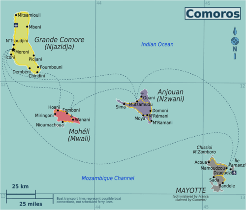
| Islands | Three main islands: Grande Comore (Ngazidja), Anjouan (Ndzuwani), Mohéli (Mwali) |
| Area | 1,861 km² |
| Population | Approximately 900,000 (2024 estimate) |
| Official Languages | Comorian (Shikomori), Arabic, and French |
| Currency | Comorian Franc (KMF) — pegged to Euro at €1 = 491.97 KMF |
| Time Zone | UTC+3 (East Africa Time; no daylight saving) |
| Electricity | 220V / 50Hz — European two-pin (Type C/E) plugs |
| International Dialing | +269 |
| Main Entry Airport | Prince Said Ibrahim International Airport, Moroni (IATA: HAH) — Grande Comore |
| Driving Side | Right-hand traffic |
⭐ Featured Comoros Tours & Safaris
No tours found matching your filters. Clear filters
Comoros as a Destination: The Perfume Islands
The Comoros archipelago produces more ylang-ylang per capita than anywhere else in the world — the sweet, floral essence used as a base note in Chanel No. 5 and hundreds of other iconic perfumes. Vanilla, cloves, and cinnamon are also cultivated extensively, giving the islands an olfactory identity as distinctive as their visual landscape. Comoros is sometimes called “The Perfume Islands,” a name that captures both its agricultural heritage and its quality of life aspiration.
Geologically, the islands are volcanic. Karthala on Grande Comore is one of the world’s most active volcanoes, with a 3 km × 4 km caldera and eruptions recorded in 2005, 2006, 2007, and 2012. The ascent to its summit (2,361 m) is one of the more challenging and rewarding hikes in the Indian Ocean region. Mohéli, the smallest island, remains the wildest — its marine park is home to hawksbill and green turtle nesting beaches, humpback whale calving grounds, and manta ray aggregations.
Key Destinations
Mount Karthala — Active Volcano Trek
The two-day ascent to Karthala’s summit crater departs from villages on Grande Comore’s western flank. The hike passes through forest, then montane heath, to the vast active caldera at the top. Local guides are essential — the route requires navigation and current volcano activity monitoring. Check with Comoros tourism authorities for current activity status before attempting the climb.
Mohéli Marine Park
Established in 2001, Mohéli Marine Park is Comoros’ only marine protected area and one of the Indian Ocean’s best-preserved reef systems. The park protects humpback whale calving grounds (June–September), green and hawksbill turtle nesting beaches (particularly Itsamia Beach), manta ray aggregations, and exceptional reef fish diversity. Accommodation on Mohéli is basic — this is a genuine off-the-beaten-track experience.
Moroni Medina
Moroni’s old medina — anchored by the Friday Mosque of Badjanani (built 1427) and its distinctive Yemeni minaret — is one of the best-preserved Arab-Swahili urban environments in the Indian Ocean. The covered market (Volo Volo), the old port with its traditional outrigger canoes (galawa), and the labyrinthine alleys of the ancient quarter offer a slice of authentic Comorian urban life rarely encountered by mass tourism.
🧭 Featured Comoros Safari Specialists
No operators found matching your criteria.
Entry Requirements & Logistics
Comoros offers visa on arrival to all nationalities — fees vary by nationality (typically USD 30–80). eVisa is also available online. Passport validity: minimum 6 months. Yellow fever certificate required if arriving from an endemic country. Note: Comoros has a history of political instability, including multiple coups. The country is generally safe for tourists but verify current conditions before travel. Inter-island connections are via domestic flights (Inter Iles Air, AB Aviation) or ferry — ferries are subject to weather and reliability issues.
Climate & Best Time to Visit
| Period | Season | Conditions & Travel Notes |
|---|---|---|
| May – Oct | Dry & Cool | Best diving visibility. Humpback whale season (Jun–Sep). Comfortable for volcano trekking. Low humidity. |
| Nov – Apr | Hot & Wet | Cyclone risk. Lush vegetation. Turtle nesting season peaks. Some inter-island ferries disrupted. |
Logistics & Precision with Moran AI
Our Moran AI Assistant utilizes real-time Comoros logistics data to assist with:
- Visa on arrival fee schedules by nationality and eVisa application guidance
- Inter-island flight and ferry schedules between Grande Comore, Anjouan, and Mohéli
- Karthala volcano current activity status and hiking safety assessment
- Mohéli Marine Park turtle nesting season calendar and accommodation availability
- Humpback whale calving season peak windows (June–September)
African Travel Center’s Commitment to Responsible Comoros Tourism
- Turtle Nesting Protection: All Mohéli beach experience operators must follow the MCZM (Mohéli Community Zone Management) protocol for turtle nesting beach access.
- Ylang-Ylang Farm Visits: Support for operators providing transparent, fair-trade plantation visits that compensate farmers directly and educate on the global perfume supply chain.
- Volcano Guide Community: All Karthala trek operators must use guides from the certified local guide cooperative to ensure community benefit and safety standards.
🏞️ Comoros Parks & Attractions
📖 Featured Comoros Post Guides
Map by By Globe-trotter – Own work based on University of Texas Library – Perry Castaneda Map Collection (public domain), CC BY-SA 3.0, Link